Vannkunsten
Stone, Water and the Making of a Neighbourhood
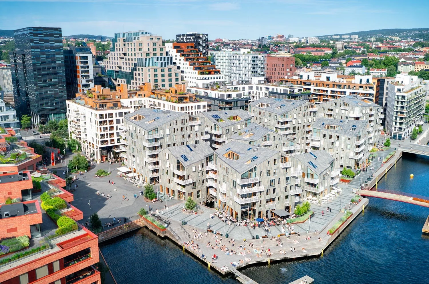
On Oslo’s waterfront, a gathering of slate-clad buildings brings the fjord into the spaces of everyday life. Vannkunsten rewards a closer look: at the stone, the shifting rooflines, the channels between homes and the public paths along their edges. To explore it is to encounter a particular ambition for the Norwegian capital: a city whose relationship with the water can be experienced at walking pace.
An architectural portrait and visitor’s guide to Bjørvika, Oslo
A different scale of Oslo
Begin with the space between two buildings.
At Vannkunsten, that narrow interval may hold a strip of water, a glimpse of the harbour or a view that changes as you move. Slate walls draw close, then give way to the sky. A roof slopes at an unexpected angle. Windows introduce the warmer presence of timber into the stone. Along the outer waterfront, the view opens again, placing these closely gathered homes within the larger scene of Bjørvika.
The buildings are immediately recognisable, yet their most interesting quality is difficult to capture in a single photograph. They make a sequence. The pleasure lies in discovering how one space leads to another, and how the same group of houses can seem compact from one direction and surprisingly open from the next.
This is an absorbing place to visit even without a particular interest in architecture. There is water to follow, material to examine and a public waterfront from which to watch the city. For those interested in urban design, there is a more specific question: how can a substantial new housing development retain the scale and variety that make a neighbourhood rewarding to walk through?
Vannkunsten offers a considered answer. Its separate buildings, irregular alignments and distinctive roofs break the development into recognisable parts. The spaces between them do much of the work. Water provides distance, reflection and a sense of openness within an unusually close arrangement of homes.
The setting sharpens the effect. Bjørvika contains some of Oslo’s most prominent cultural buildings and most conspicuous contemporary architecture. Vannkunsten belongs to that transformation, while giving it a domestic register. Its windows are the windows of homes; its waterside spaces belong to the daily geography of a neighbourhood.
That combination gives the visitor a useful way of approaching the place. Look carefully, move slowly, and remember that the scene continues after the sightseeing is over.
Finding Vannkunsten on the map
Vannkunsten stands in Bispevika, within the wider Bjørvika waterfront area of central Oslo. The Oslo Opera House and MUNCH are nearby landmarks, while Oslo Central Station, generally signposted as Oslo S, connects the neighbourhood to the rest of the city and to the national railway network.
Several names recur here, and each describes something different. Bjørvika is the broader waterfront district. Bispevika identifies the part of that waterfront in which Vannkunsten is located. Bispekilen is the long, wedge-shaped public water space between the northern and southern parts of the development. Rostockgata forms Vannkunsten’s inland edge.
Oslobukta is another name visitors will encounter on signs and websites. It is used for the area’s collection of shops, restaurants and other destinations at street level, across several parts of Bjørvika. Follow it when looking for places to eat, shop or spend time in the neighbourhood.
Vannkunsten itself is a residential development with commercial premises and public spaces around it. Arrive from a city street or along the promenade: either approach introduces the architecture through its relationship with the surrounding neighbourhood.
Its name also records its authorship. The buildings were designed by the Danish practice Tegnestuen Vandkunsten, usually called Vandkunsten Architects in English. The Oslo development uses the Norwegian spelling, Vannkunsten. The similarity is deliberate: the project took its name from the architectural practice.
A city returns to its waterfront
To understand Vannkunsten, it helps to imagine Bjørvika before the cultural buildings, new housing and waterside walks.
Port operations and major roads once occupied much of this part of central Oslo. The fjord was close to the city in geographical terms, but large areas of the waterfront were difficult to experience as ordinary public space. The subsequent redevelopment changed the relationship between the centre and the shore.
The municipal Fjord City project, or Fjordbyen, provided the wider framework. Planning began in 2000, and Oslo’s city council adopted the zoning plan for Bjørvika in 2003. The intention was to give former harbour land new uses, including housing, employment and recreation, while opening the city towards the fjord.
This transformation is larger than any individual building. Streets, waterfront paths and public spaces are essential to it. The Havnepromenaden, Oslo’s harbour promenade, gives the shoreline a continuous identity even where individual stretches have different characters.
Vannkunsten is best understood within this network. A visitor can move between major cultural institutions, places to eat, residential streets and open water without treating each as a separate excursion. The buildings matter, but so do the connections that allow the city to reach them.
The waterfront’s change should not obscure its earlier life. Contemporary Bjørvika occupies ground shaped by centuries of harbour activity and changing shorelines. Some of that history is visible in the interpretation of its public spaces; much more has emerged through archaeological investigation.
The new facades can make this history difficult to imagine. Yet the waterfront has been remade before, through harbour construction, reclamation and changes in use. Vannkunsten belongs to that continuing story. Its apparent newness is only the most visible layer.
From a competition to fourteen buildings
Vandkunsten won the architectural competition for two sites in Bispevika in 2012. The project developed in two principal phases, on either side of Bispekilen.
The original northern group comprises nine buildings containing 215 apartments. The first homes were ready in 2020. These are the grey slate-clad buildings that established Vannkunsten’s identity and appear in many of its best-known early photographs.
The second group, Vannkunsten Syd, adds five buildings south of Bispekilen. Together, the two phases form a composition of fourteen buildings. The southern phase continues the characteristic roof forms and close relationship with the water, while introducing a different Norwegian slate.
This distinction matters when reading about the development. Earlier descriptions often use the name Vannkunsten for the original nine-building project alone. A visitor exploring the completed northern and southern groups encounters a larger ensemble.
Oslo S Utvikling, commonly abbreviated to OSU, is the developer. Alongside Vandkunsten’s architecture, landscape practice Grindaker has contributed to the outdoor environment. Bispekilen is a related but distinct public-space project, designed by SLA and completed in 2023.
The original Vannkunsten received the Norwegian construction industry’s Building of the Year award for 2021, presented at Byggedagene in June 2022. It subsequently received Houens fonds diplom in 2023, an architectural distinction awarded through Norway’s National Museum and the National Association of Norwegian Architects.
The awards draw attention to what a distant photograph can leave out: the arrangement of the buildings and the quality of the spaces they make together.
The architecture of intervals
The architects’ starting point was the Norwegian archipelago: the movement from exposed water into sheltered passages, and the changing relationships between islands, rocks and the sea.
At Vannkunsten, this becomes a way of arranging buildings. Compact volumes stand close together but turn in different directions. Openings appear between them, and views continue through the development. The group can be read as an urban counterpart to the fragmented edge of a coastline.
Its density is worth noticing. Vannkunsten can appear village-like in photographs, but the original buildings rise from four to eight storeys. Their different sizes and asymmetrical pitched roofs make that amount of accommodation easier to read as a collection of individual houses.
The roof is particularly important. It gives each building a recognisable top, while the continuing slate surface joins roof and wall into a coherent whole. Within that common material language, changes of height, angle and proportion distinguish one building from another.
In the Houens fonds assessment, the jury identified the way the buildings turn to create changing spaces and sightlines. It also noted the progression in scale, with lower buildings towards the water. These are useful things to look for on a visit: where the group opens, how the skyline steps, and which views survive between the volumes.
One way to read the architecture is as a negotiation between proximity and distance. The buildings are near enough to make intimate spaces, yet the gaps keep the larger setting in view. A short stretch of water can separate a home from a public path while allowing the two to remain visually connected.
This interpretation helps explain why walking is so rewarding here. The spaces are encountered gradually. An aerial image reveals the composition; a route at ground level reveals its consequences.
Two kinds of Norwegian stone
Slate gives Vannkunsten much of its character. It covers walls and pitched roofs, giving the buildings a material continuity that is visible even from across the water.
The northern group uses grey slate from Oppdal. AF Gruppen’s account of its construction identifies Palmer Gotheim Skiferbrudd as the supplier and describes the skilled work involved in splitting, assessing and cutting the stone. The pieces were prepared with sawn edges and varying lengths for the project.
These details reward a close view from the public paths. At a distance, the cladding helps each building read as a single volume. Nearby, the eye begins to register individual pieces, their joints and the variation within the surface. The effect depends on both the natural material and the precision with which it has been assembled.
Vannkunsten Syd uses Otta slate of the variety known as Rust. Its iron-bearing minerals produce reddish and golden tones as the material weathers. Some pieces already had rust colouring when installed, so variation was present from the beginning.
The distinction gives the two groups a subtle material identity of their own. In the north, grey Oppdal slate establishes a cooler palette. In the south, the changing colours of Otta slate introduce a warmer register. Their shared forms hold the ensemble together.
The southern facades introduce time into the composition. Their appearance is intended to change, so returning visitors may encounter a different balance of colour in the same group of buildings. The finished architecture continues to acquire a patina.
Timber details provide another scale of attention. Oak appears around windows and other openings in the original development, and in the southern homes’ detailing. Against the extensive slate surfaces, these smaller elements help draw the eye towards the places where people look out, enter and inhabit the buildings.
For a visitor, the most revealing comparison is simple: examine the two groups in the same light. Let the differences in stone emerge before looking for differences in form.
Water as part of the plan
At Vannkunsten, water helps organise the development. The fjord is present in the broad outer view, while channels and sheltered water spaces bring it into a much closer relationship with the buildings.
The architects describe a progression between public waterfront and more domestic, sheltered spaces. Their account also explains that water is raised locally to bring its surface closer to the level of daily life. The apparent ease of the composition therefore rests on deliberate design and engineering.
The buildings are permanent structures. Their resemblance to an archipelago is an architectural idea, expressed through their placement, the water around them and the passages that connect the development to the city.
Landscape design is integral to that experience. Grindaker’s work on the northern phase extended from preliminary design to the completed outdoor environment. The relationship between paved ground, planting, water and buildings determines how the project is encountered at close range.
Water also affects how a visitor sees the architecture. Reflections repeat or fragment a facade; an open surface creates visual space where another building might otherwise stand. A channel can guide the eye towards the harbour, while a bridge changes the angle from which the group is understood.
Follow that transition from the inland streets to the promenade. Near the buildings, water is measured in the width of a channel or the distance across a sheltered basin. At the outer edge, the view belongs to the fjord again.
Bispekilen and the older harbour
Bispekilen deserves time in its own right. This public water space separates the two phases of Vannkunsten and establishes a connection, through its alignment, between the medieval city and the fjord.
Its direction follows the sightline from Gamlebyen and Middelalderparken towards Akershus. Along its edges, quays provide places to walk and pause. A pedestrian bridge links the waterfront beside the northern and southern buildings, while Rostockgata crosses farther inland.
At the inner end, the water feature recalls the historical meeting of the Alna River and the sea. Bjørvika Utvikling explains that seawater is pumped into the upper basin and flows down into Bispekilen. This is a designed evocation of the former river mouth.
The steps contain another layer of interpretation. Drawings in the concrete illustrate changes in the shoreline over roughly a thousand years. They invite the visitor to imagine how different the relationship between land and water has been at earlier moments in Oslo’s history.
Archaeology provides tangible evidence of that older waterfront. During investigations in Bispekilen in May and June 2020, the Norwegian Maritime Museum documented harbour remains and a substantial wooden vessel known as Bispevika 24. The account published by Bjørvika Utvikling records that the boat was found between earlier wharf foundations. Analysis of its timber suggested trees felled shortly after 1567.
The find is a valuable reminder of the site’s timescale. The canals and slate-clad homes belong to a new chapter, but maritime activity here reaches much further back. The excavated vessel is part of the archaeological story; visitors should not expect to see it displayed in the present-day basin.
Pause beside Bispekilen with that history in mind. The water in front of you occupies a carefully designed public space, yet the questions it raises are older ones: where the city ends, where the harbour begins, and how that boundary changes.
A neighbourhood to share
Vannkunsten’s public appeal depends on its life as a residential place. The buildings contain private homes; the outer waterfront connects them to a wider city of pedestrians, diners and visitors.
The architects explicitly considered different degrees of public and private space. A visitor’s route along the promenade and a resident’s relationship with a sheltered waterside terrace have different purposes. Their closeness is part of the project’s character.
This gives the development an interest beyond its appearance. Attractive housing and an inviting public waterfront can occupy the same small piece of city, but the relationship requires care. Sightlines may pass across water into domestic spaces. A place that feels quiet and secluded may be someone’s immediate home environment.
The appropriate response is ordinary consideration. Follow public routes, leave residential entrances clear and treat terraces, small jetties and residents’ facilities according to their signs and boundaries. Photography should concentrate on the architecture without intruding into homes.
There is also a distinction between enjoying the neighbourhood and buying something in it. Public waterfront space allows a visit to be as simple as a walk and a pause beside the water. Restaurants and other businesses add further ways of spending time here, each with its own arrangements.
Vannkunsten brings material, form, water and everyday use into unusually close relation. It asks for attention at several distances: across the bay, along the promenade and beside a single carefully framed window.
After exploring the close views, step back towards the open waterfront. The separate buildings gather into a skyline again. What seemed a collection of sculptural objects begins to read as a small piece of city, with the fjord running through its design.
THE VISITOR’S GUIDE
Planning your visit
Vannkunsten is best explored on foot, with enough time to move between its inland edges, the public promenade and Bispekilen. You can visit independently; no admission ticket is needed for the public streets and waterfront paths.
Allow about 45 to 90 minutes for a considered look at the development and Bispekilen. Half an hour can provide a useful introduction if you are already nearby. With a meal, the Opera House, Deichman Bjørvika or MUNCH, the visit can comfortably become a half-day or longer. These are suggested allowances, rather than official tour durations.
Daylight is helpful for examining the materials and understanding the layout. An additional visit towards evening offers another way to see the rooflines and waterfront, but access to individual businesses and facilities follows their own opening hours.
Use Vannkunsten, Bispekilen and Rostockgata as map search terms. The southern development is also identified as Vannkunsten Syd; Syd means south. For orientation, the City of Oslo lists its address range as Rostockgata 61–85. The development extends beyond a single street number, so choose your destination according to the part you want to see.
Wear comfortable shoes and bring a layer suitable for wind by the water. In wet or cold conditions, pay particular attention to exposed surfaces and waterside steps. For a short winter visit, a nearby indoor stop can make the outing more comfortable.
The main things to look for are the changing alignments of the buildings, the difference between the two slates, the relationship between roofs and walls, and the transition from public waterfront to more sheltered spaces. Bispekilen adds a fifth subject: the older shoreline beneath the new city.
Getting there
From Oslo Central Station
Oslo S is the most useful arrival point for many international visitors. As a planning allowance, expect roughly 10 to 20 minutes on foot to Vannkunsten, depending on your station exit, chosen route, pace and destination within the development. Allow longer for crossings, mobility needs or stops along the way.
A straightforward approach is to head towards Bjørvika and the Opera House, then continue east along Operagata towards the Vannkunsten area and Rostockgata. This also provides an introduction to the surrounding cultural quarter. Use a live pedestrian map for the final approach, particularly when local works affect a path.
From elsewhere in Oslo
Use Ruter’s journey planner or app for travel by local public transport. Bjørvika is a useful nearby stop to search for, while Jernbanetorget serves the central station area and connects with the metro. Select your actual destination on the map to compare the final walking distances.
Central Oslo is in Ruter’s Zone 1. The correct ticket depends on the whole journey, so enter both your starting point and destination. Check current routes and ticket arrangements before travelling; the most useful service can change with your point of departure or temporary works.
From Oslo Airport
Oslo Airport at Gardermoen, airport code OSL, has direct rail connections to Oslo S. Both Vy services and the Airport Express Train, Flytoget, serve the route. Avinor gives an approximate train journey of 20 minutes to the city centre. Actual timings, ticket validity and fares depend on the service.
Continue from Oslo S on foot or use a suitable local connection. If arriving at a different airport, check its transport arrangements separately: these directions apply specifically to Oslo Airport at Gardermoen.
By bicycle, taxi or car
For a bicycle visit, leave the bicycle at an appropriate parking place and explore the closer spaces on foot. This makes it easier to stop without obstructing other people. A taxi is useful when mobility or luggage makes walking inconvenient; provide a specific street address or business name. If driving, identify a public car park in advance and complete the visit on foot.
A self-guided walk in six stages
This suggested route starts at the northern end and continues south across Bispekilen. Its purpose is to guide attention as well as movement. Use the public streets and promenade, observing local signs where routes meet residential areas.
Approach from the city
Begin around Operagata and the northern Vannkunsten buildings. Before going towards the water, consider the change in scale between the broader city streets and the closely gathered slate-clad houses.
Look upwards. Follow the roof profiles across more than one building. The shared material gives the group coherence, while differences in height and angle prevent the skyline from becoming a single repeated shape. This first view introduces the development’s balance between consistency and variation.
Examine the northern buildings
Move towards the public waterfront around the original group. Where a public route gives a close view, look at the slate pieces and the timber around openings. Compare the surface at arm’s-length viewing distance with the impression from farther away.
Then look through the gaps. Notice which views continue towards the water, and how a small change in your position can alter the relationship between two buildings. Keep to clearly public routes rather than following a promising view into a residential access area.
Pause at Bispekilen’s waterfront bridge
At the seaward end of Bispekilen, the pedestrian bridge gives a useful overview of the relationship between water and buildings. Pause where there is room for others to pass.
Look inland along the basin, then turn back towards the wider waterfront. The two views explain the change from the long, contained water space to the openness of the bay. They also make the relationship between Vannkunsten’s northern and southern groups easier to understand.
Follow Bispekilen inland
Take time to explore the public edges towards the inner end and its steps. Look for the shoreline drawings in the concrete and the water feature that refers to the former river mouth.
This is the historical pause in the walk. Imagine the harbour before the present streets, remembering that archaeological investigations here uncovered earlier wharves and a vessel built from sixteenth-century timber. The contemporary landscape gives a point of access to that history without reconstructing the old harbour.
Continue to Vannkunsten Syd
Return towards the waterfront crossing and continue beside the southern buildings. Compare the slate with the northern group while the earlier impressions are still fresh.
Look for the warmer colouring in the Otta stone, then examine the ways the buildings turn towards one another and the water. Follow the public promenade, taking particular care to distinguish it from private waterside facilities. A view across a channel is often enough to understand a space; entering it is not always necessary or appropriate.
Finish with a longer view
End at an open point on the public waterfront where you can see several buildings together. After the close attention to details, allow the group to become a composition again.
If continuing towards MUNCH and the Opera House, use the public waterfront routes around the bay. This wider circuit helps place Vannkunsten within Bjørvika. The change of viewpoint is part of the pleasure: the buildings you have just studied at close range become a recognisable element in the larger waterfront.
Making a day of Bjørvika
The Oslo Opera House
Snøhetta’s Opera House offers a different architectural encounter with the fjord. Its sloping roof was conceived as an accessible public landscape, and the building’s principal materials include white Carrara marble, oak and aluminium.
Visit the exterior and public areas according to current access arrangements, or book a performance or guided tour. The roof is exposed to the weather; follow any restrictions and choose a route suited to the conditions. From an architectural perspective, it is rewarding to compare the broad public surface of the Opera House with Vannkunsten’s smaller spaces and multiple roof forms.
Deichman Bjørvika
Oslo’s main public library stands close to the Opera House. Designed by Atelier Oslo and Lundhagem, it opened to the public in June 2020. It offers a welcoming indoor addition to an architectural walk, with places to read, explore and enjoy views towards the fjord.
The library also houses the dedicated room for Katie Paterson’s Future Library, an artwork unfolding from 2014 to 2114. Manuscripts are held there for publication at the end of the project. Consult Deichman’s current information about access, and allow time to explore the library’s other public spaces.
MUNCH
MUNCH is the major museum devoted to Edvard Munch on Bjørvika’s waterfront. Its visitor programme includes the artist’s work alongside other exhibitions and events. A visit can provide the main indoor focus of a day that includes Vannkunsten.
Choose exhibitions according to your interests and book through the museum’s official website. Check its current arrangements for timed entry, accessibility and bags before arrival. Allow a separate block of time for the museum instead of treating it as a brief stop between outdoor sights.
The Mother
South of MUNCH, at Inger Munch’s Pier, stands The Mother, Tracey Emin’s large bronze sculpture. Installed in 2022, the kneeling figure occupies a landscaped setting beside the water. It offers another reason to extend a waterfront walk beyond the museum entrance.
The sculpture invites a different pace of looking from the surrounding buildings. Approach it as an individual work, then consider its position within the broader waterfront. The meeting of art, landscape and daily movement is another recurring feature of Bjørvika.
Barcode and the wider waterfront
For a broader architectural walk, include the Barcode buildings and Akrobaten pedestrian bridge. Their forms add another scale and character to the experience of Bjørvika. Vannkunsten is easier to appreciate when seen alongside the different architectural decisions around it.
Choose a manageable combination. Vannkunsten, Bispekilen and one major cultural visit make a satisfying programme without requiring the whole neighbourhood to be covered at once.
Eating, drinking and taking a break
A meal is a useful way to give the waterfront more time. Explore the businesses around Rostockgata and the public promenade, and use the Oslobukta directory and VisitOSLO for current options throughout the neighbourhood.
Two addresses within Vannkunsten Syd illustrate the local choice at the time of this edition.
Corso, at Rostockgata 61, is an Italian-inspired restaurant whose offer draws on Norwegian seasonal ingredients. Its location beside the canal makes it relevant to a visit focused on Vannkunsten itself. Consult the restaurant directly for its current menu, opening hours and reservations.
Libertine, at Rostockgata 69, is a food and wine bar in Vannkunsten Syd. Its own description emphasises wines, particularly from France, accompanied by small dishes. When booking, select the Vannkunsten location, as Libertine also has a Frogner address.
Both addresses were checked for this edition. For later visits, confirm the current menus and opening arrangements before making a special journey.
For a simpler break, choose a café or takeaway option that suits the day’s route and weather. A short indoor pause can be particularly welcome in winter. If a meal must fit around a museum entry or performance, book with enough time between them and mention any dietary requirements when reserving.
For a low-cost visit, the public architecture walk can stand on its own. There is no requirement to dine in order to enjoy the public waterfront.
Seasons, light and photography
Vannkunsten can be visited throughout the year. The best time depends on the kind of experience you want: a long outdoor afternoon, a short architectural study, a waterside meal or a visit combined with museums.
Spring and autumn suit a flexible plan built around the weather. Bring an extra layer and leave room for an indoor stop. The architectural interest does not depend on a sunny day: even light can make the differences between surfaces easier to examine.
Summer offers long evenings and more scope to combine the walk with outdoor dining, a sauna session or a visit to a designated bathing place. Popular waterfront venues can be busy, so reserve a particular restaurant or activity if it is central to your plans.
Winter makes footwear, daylight and the condition of paths more important. Keep the outdoor route adaptable and allow time to warm up. Snow and ice conditions vary; check the forecast rather than building the visit around a particular winter scene.
For photography, try three distances. Start with a wider view that includes several buildings and some open water. Move closer to study the overlaps between roofs and facades. Finish with a material detail, such as slate beside a timber-framed opening.
Reflections offer another approach when conditions allow. A still surface may clarify a building’s outline, while ripples break it into something less definite. Let the available light guide the composition rather than expecting a single ideal angle to work at every hour.
The public bridge at Bispekilen and the outer promenade are useful places to begin looking. Move aside before stopping, keep entrances and narrow passages clear, and avoid photographing directly into homes. Good images can describe the relationship between architecture and water while respecting the people who live there.
Access, comfort and visiting with children
Plan an accessible visit around the main public streets and promenade, then assess optional detours separately. Waterside steps, changes of level, narrower passages and temporary works can affect a route. An attractive viewpoint should not be assumed to have the same access as the main path leading towards it.
If step-free access is essential, check the approach and your intended indoor stops in advance. Ask a restaurant about its entrance and toilet arrangements, and use the published accessibility information for MUNCH and the Opera House. Ruter provides information about travelling with a wheelchair or pushchair and about accessible stops and services.
For a combined visit, confirm access at each planned stop. In winter, allow for changes caused by snow, ice and maintenance.
For families, turn the walk into a simple exercise in noticing. Count different roof shapes, compare grey and rust-coloured stone, or find a building reflected in the water. Short distances can still provide plenty to look at.
Stay close to young children around channels, quays and steps. Vannkunsten is a residential waterfront, with water edges that require attention. For longer play or bathing time, make a separate plan for a suitable nearby facility.
Use an indoor stop when needed rather than extending a cold or tiring walk. Deichman Bjørvika has activities and spaces for younger visitors, while other nearby cultural venues publish their own family information.
The Opera House lists toilets in its public foyer, available during the building’s opening hours. MUNCH publishes details of accessible toilets and baby-changing facilities for museum visitors. Oslo S has luggage lockers, a practical option if you are visiting between trains or before checking into accommodation.
Swimming, saunas and the fjord
A walk at Vannkunsten can be combined with Oslo’s waterside bathing and sauna culture, but plan the water activity as a separate part of the visit. The development’s channels and residential jetties should not be treated as general swimming facilities.
Operastranda, beside the Opera House, and Sørenga sjøbad are established nearby bathing destinations. Sørenga includes a seawater swimming area, a sandy area, places to sit and visitor facilities. Consult the municipality’s information for current access, facilities and water quality before going.
Water quality can change. The City of Oslo advises against swimming for at least 24 hours after heavy rain and publishes information for designated bathing places. Check current advice on the day; the appearance of the water is not a reliable substitute for it.
For a sauna visit, Oslo Badstuforening operates at Sukkerbiten, south of the Opera House, among other locations. Its booking system offers shared sessions and private bookings. Reserve through the operator and follow its instructions about arrival, clothing, towels and use of the facilities.
You can enjoy a sauna visit without making a cold-water swim part of the plan. Choose activities appropriate to your ability and the conditions, and follow the staff’s guidance. A warm indoor break and a waterfront walk can also be a complete winter outing.
When extending the walk towards Sørenga, check the currently available pedestrian route. Links around a working and developing waterfront can be affected by maintenance or local works.
Three ways to organise the visit
An hour for architecture
Go directly to Vannkunsten, explore the northern public waterfront, pause at Bispekilen and compare the southern buildings. Keep the programme focused on the development itself. This is a useful option between other appointments or for visitors with a particular interest in materials and urban design.
A half-day beside the water
Begin with the Opera House and a look inside Deichman Bjørvika during opening hours. Continue to Vannkunsten and Bispekilen, then allow time for lunch or coffee. Keep the museum for another visit if you prefer an unhurried pace.
A day of art, architecture and the fjord
Combine a reserved MUNCH visit with Vannkunsten, Bispekilen and a meal. Add The Mother and a broader waterfront walk if time and energy permit. A sauna session can be an alternative to part of the walking programme rather than an obligation to fit in everything.
In each case, leave some unallocated time. Vannkunsten’s interest is partly in the small decisions a visitor can make on arrival: following a view, returning to a detail or staying longer beside a stretch of water.
Useful information for international visitors
Money and language
Norway uses the Norwegian krone, abbreviated NOK. Cards are widely accepted, and English is widely understood. Keep the Norwegian place names when searching maps and transport services; they are the names you will see locally.
Drinking water
Tap water in Oslo is safe to drink unless a specific local notice says otherwise. Carrying a refillable bottle is practical for a longer day on foot.
Tourist information
Oslo Visitor Centre is in Østbanehallen, part of the central station complex, at Jernbanetorget 1. It is a useful place to ask about current routes, visitor services and the wider city.
Emergencies
Norway’s emergency numbers are 110 for fire, 112 for police and 113 for medical emergencies. When giving a location, use the nearest street address or identifiable landmark.
Before setting out
Check the weather, any essential transport connection and the opening hours of the businesses or cultural venues you intend to visit. For swimming, add the municipality’s latest bathing-water advice. The architecture will reward a return visit; the practical arrangements should be checked for the day you go.
Sources and official websites for planning
Oslo tourism, maps, seasonal information and visitor services: OSLO
Local public transport and journey planning: ruter.no/en
National journey planning: entur.no
Oslo Airport: avinor.no/en/airport/oslo
Train operators: vy.no/en and flytoget.no/en
Oslo Opera House: operaen.no/en
Deichman public libraries: deichman.no
MUNCH: munch.no/en
Neighbourhood shops and restaurants: oslobukta.no/en
Oslo Sauna Association: oslobadstuforening.no/en
City of Oslo, including bathing places and municipal visitor information: oslo.kommune.no